默尔特-摩泽尔省市镇
法国默尔特-摩泽尔省市镇南锡区
丢卢阿尔
维基百科,自由的百科全书
跳到导航
跳到搜索
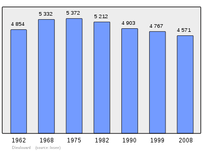
丢卢阿尔(法語:Dieulouard)是法国默尔特-摩泽尔省的一个市镇,位于该省南部,属于南锡区(Nancy)。该市镇总面积17.69平方公里,2009年时的人口为4568人。[1]
人口
丢卢阿尔人口变化图示
参见
参考文献
默尔特-摩泽尔省市鎮 
|
|---|
| | 省会 |
南锡 |
|---|
| | 副省会 |
布里埃 · 吕内维勒 · 图勒
|
|---|
| | 其它市镇 |
阿博库尔 · 阿贝维尔莱孔夫朗 · 阿邦库尔 · 阿弗莱维勒 · 阿弗拉库尔 · 阿然库尔 · 安热赖 · 阿兰 · 阿拉蒙 · 阿朗普 · 阿隆德雷勒拉马勒迈松 · 阿芒克 · 阿芒翁库尔 · 昂塞尔维莱 · 昂代尔尼 · 昂迪伊 · 昂戈蒙 · Anoux · 昂索维尔 · 昂特吕 · 阿尔莫库尔 · 阿尔纳维尔 · 阿拉库尔 · 阿赖和昂 · 默尔特河畔阿尔 · 阿蒂安维勒 · 阿通 · 欧布埃 · 欧丹勒罗芒 · 欧特尔皮耶尔 · 摩泽尔河畔欧特尔维勒 · Autrey · 阿维莱尔 · 阿夫兰维尔 · 阿夫里库尔 · 阿夫里 · 阿泽洛 · 阿澤拉耶 · 巴卡拉 · 巴东维莱 · 巴尼厄 · 镜中班维勒 · 马东河畔班维勒 · 巴尔巴 · 巴尔邦维勒 · 巴里塞奥普兰 · 巴里塞拉科特 · 莱巴罗什 · 巴斯利厄 · 巴泰莱蒙莱博泽蒙 · 巴蒂利 · 巴蒂尼 · 博泽蒙 · 巴永 · 马河畔拜翁维尔 · 巴宰伊 · 博蒙 · 贝尚普 · 贝洛 · 美丽城 · 贝纳梅尼 · 伯内 · 贝尔内库尔 · 贝尔特朗布瓦 · 贝尔特里尚普 · 贝坦维莱尔 · 伯韦尔 · 伯韦赞 · 伯维莱 · 塞伊河畔贝 · 大伯藏日 · 伯佐蒙 · 比屈埃莱 · 小比安维尔 · 比翁维尔 · 水边布兰维勒 · 布拉蒙 · Blémerey · 穆松桥旁布莱诺 · 布莱诺莱图 · 布瓦斯蒙 · 邦库尔 · 邦维莱 · Borville · 布克 · 布伊隆维尔 · 布夫龙 · 橡树布歇尔 · 布歇尔之妇 · 布克西埃苏弗鲁瓦德蒙 · 布藏维尔 · 布兰维尔 · 布拉勒维勒 · Bratte · 布雷安拉维尔 · 布雷梅尼 · 布雷蒙库尔 · 塞伊河畔布兰 · 布鲁维尔 · 布吕莱 · 布吕维勒 · 比伊松库尔 · 比利尼 · 比雷 · 比里维尔 · 比尔泰库尔奥谢内 · 森特雷 · 塞尔维尔 · 沙利尼 · 尚布莱比西埃 · 尚珀努 · 莫塞尔河畔尚佩 · 尚皮尼厄勒 · 尚泰厄 · 绍伊莱 · 沙朗西韦赞 · 沙雷 · 沙尔梅拉科特 · 沙尔穆瓦 · 摩泽尔河畔绍德内 · Chavigny · 阿勒布河畔沙泽勒 · 谢内维埃 · 谢尼库尔 · 舍涅尔 · 绍卢瓦梅尼奥 · 韦祖兹河畔西雷 · 克莱厄雷 · 克莱默里 · 布雷农河畔克莱雷 · 宽库尔 · 科尔梅 · 科隆贝莱贝勒 · 雅尔尼西地区孔夫朗 · 孔拉格朗德维勒 · 科讷和罗曼 · 库尔贝索 · 库尔瑟莱 · 夸维莱 · 克朗特诺瓦 · 克雷佩 · 克雷韦尚 · 克雷维克 · 克雷济伊 · 克里翁 · 克鲁瓦斯马尔 · 克吕斯内 · 屈斯提讷 · Cutry · 当姆勒维耶尔 · 当维图 · 德纳夫尔 · 德克斯维尔 · 迪阿尔维勒 · 丢卢阿尔 · 多勒库尔 · 默尔特河畔东巴勒 · 艾埃地区多梅夫尔 · 韦祖兹河畔多梅夫尔 · 东热尔曼 · 东热万 · 多马里厄勒蒙 · 多马尔特蒙 · 多马尔坦拉绍塞埃 · 图勒旁多马丁 · 多马尔坦苏阿芒克 · 东普里 · 莱地区东普泰 · 东库尔莱孔夫朗 · 东库尔莱隆吉翁 · 德鲁维勒 · 埃克鲁韦 · 安沃 · 安维尔奥雅尔 · 昂贝尔梅尼 · 谢尔河畔埃皮耶 · 埃普利 · 阿默聚勒河畔埃尔贝维莱 · 埃尔鲁维尔 · 埃塞和迈泽赖 · 埃塞拉科特 · 南锡旁埃塞 · 埃特勒瓦 · 厄勒蒙 · 厄韦赞 · 福尔 · 法维耶尔 · 费科库尔 · 费纳维莱 · 弗尔里埃 · 艾埃地区费 · 菲利埃 · 弗兰瓦勒 · 摩泽尔河畔弗拉维尼 · 南锡前弗莱维勒 · 弗莱维尔利克西埃 · 弗兰 · 弗利雷 · 丰唐瓦拉茹特 · 摩泽尔河畔丰特努瓦 · 福尔塞勒圣戈尔贡 · 福尔瑟莱苏居盖伊 · 富 · 弗兰布瓦 · 桑图瓦地区弗赖斯内 · 弗朗什维勒 · Franconville · 弗雷梅尼 · 弗雷蒙维勒 · 弗雷努瓦山 · 弗里奥维尔 · 弗罗卢瓦 · 弗鲁阿尔 · Froville · 热拉库尔 · 热洛库尔 · 热朗翁库尔 · 热蒙维尔 · 热尔贝库尔和阿普莱蒙 · 热尔贝维莱 · 热尔米尼 · 热尔蒙维勒 · 热宗库尔 · 吉博梅 · 吉罗蒙 · 吉里维莱 · 格隆维尔 · 戈盖伊 · 贡德雷库尔艾 · 贡德尔维勒 · 贡德勒克松 · 戈尔西 · 戈维莱 · 格朗费利 · 格里蒙维莱 · 格里波尔 · 格里斯库尔 · 格罗斯鲁夫雷 · 居涅 · 吉 · 阿布兰维尔 · 阿热维尔 · 艾盖维尔 · 阿洛维尔 · 阿默维尔 · 阿蒙维尔 · 昂德旺皮耶尔雷蓬 · 阿农维尔叙泽蒙 · Haraucourt · 阿尔布埃 · 阿鲁埃 · 阿特里兹 · 欧库尔穆兰 · 奥东维尔 · 奥松维尔 · 埃伊库尔 · 埃纳梅尼勒 · 埃尔贝维莱 · 埃里梅尼 · 埃尔瑟朗日 · 奥埃维尔 · 奥梅库尔 · 乌代勒蒙 · 乌德蒙 · 乌德勒维尔 · 乌塞维尔 · 于迪维莱 · 于西尼戈布朗日 · 伊盖伊 · 热隆 · 雅尔尼 · 雅维勒拉马勒格朗日 · 若尔尼 · 让德兰库尔 · 让代利兹 · 热翁库尔 · 热赞维尔 · 熱夫 · Jolivet · 若佩库尔 · 茹阿维尔 · 茹德勒维尔 · 瑞夫雷库尔 · 拉布里 · 拉沙佩尔 · 拉涅 · 莱特尔苏阿芒克 · 莱 · 拉勒夫 · 拉马特 · 朗代库尔 · 朗德雷蒙 · 朗德尔 · 拉讷韦洛特 · 拉讷夫维勒欧布瓦 · 富后拉讷夫维勒 · 巴永前拉讷夫维勒 · 南锡前拉讷夫维勒 · 朗弗鲁瓦库尔 · 朗泰丰坦 · 拉龙克斯 · 拉克苏 · 来圣克里斯托夫 · 来圣雷米 · 勒伯维尔 · 兰特雷 · 勒曼维勒 · 勒梅尼勒米特里 · 朗翁库尔 · 莱斯梅尼尔 · 莱特里库尔 · 勒克西 · 莱尔 · 利梅雷默诺维尔 · 利龙维尔 · 利韦尔丹 · 卢瓦西 · 隆格拉维尔 · 隆圭永 · 隆维 · 洛雷 · 洛罗蒙特泽 · 吕贝 · 吕塞 · Ludres · 吕普库尔 · 马涅尔 · 迈迪埃 · 塞尔河畔迈利 · 迈里曼维尔 · 迈克斯 · 麦济耶尔 · 马拉维莱尔 · 马勒卢瓦 · 马勒泽维勒 · 马梅 · 芒克 · 芒谢于莱 · 芒德尔之四塔 · 芒贡维勒 · 韦尔穆瓦地区芒农库尔 · 沃埃夫尔地区马农库尔 · 芒翁维尔 · 芒翁维莱 · 马兰维莱 · 马尔巴什 · 马龙 · 马尔拉图 · 马尔特蒙 · 马尔坦库尔 · 马特克塞 · Maxéville · 马泽吕勒 · 梅翁库尔 · 梅尼拉图 · 下梅尔西 · 上梅尔西 · 梅雷维勒 · 梅尔维莱 · 梅桑 · 默克西 · 米涅维尔 · 米勒里 · 曼奥尔维尔 · 穆瓦纳维尔 · 穆瓦夫龙 · 吕内维勒旁蒙塞勒 · 塞伊河畔蒙塞勒 · 蒙邦维莱 · 蒙托维尔 · 蒙特诺瓦 · 蒙蒂尼 · 歇尔河畔蒙提尼 · 蒙莱特鲁瓦 · 蒙莱维尼奥布尔 · 蒙特勒 · 蒙圣马丁 · 默尔特河畔蒙 · 莫尔丰坦 · 莫里维莱 · 塞伊河畔莫尔维勒 · 穆阿库尔 · 穆阿维尔 · 穆松 · 穆蒂耶尔 · 穆特罗 · 穆瓦昂 · 米尔维勒 · 九间房 · 新房 · 巴东维莱旁讷维莱 · 摩泽尔河畔讷维莱 · 诺默尼 · 诺尼尼 · 诺鲁瓦勒塞克 · 穆松桥旁诺鲁瓦 · 诺维昂奥普雷 · 奥谢 · 奥热维莱 · 奥涅维勒 · 奥莱 · 奥梅勒蒙 · 翁维勒 · 榆和城 · 奥特 · 奥泽赖莱 · 巴里讷后帕涅 · 摩泽尔河畔帕尼 · 帕内 · 帕雷圣塞赛尔 · 帕尔鲁瓦 · 帕吕 · 佩蒂费利 · 佩蒂特蒙 · 佩通维尔 · 珀克松 · Phlin · 片讷 · 皮耶尔拉特雷什 · 皮耶尔佩尔塞 · 皮耶尔雷蓬 · 皮耶尔维勒 · 蓬佩 · 穆松桥 · 圣万森桥 · 塞伊河畔波尔 · 普赖埃 · 普雷尼 · 普勒坦伊尼 · 皮利尼 · 皮尔内 · 皮勒诺瓦 · 皮克斯 · 皮克西厄 · 戈维永库尔 · 朗莱洛 · 罗库尔 · 桑翁河畔拉维尔 · 小雷希库尔 · 雷克隆维尔 · 勒安维莱 · 雷埃尔雷 · 雷翁 · 雷隆 · 马河畔朗贝尔库尔 · 勒芒诺维勒 · 雷梅雷维勒 · 雷蒙库尔 · 雷佩 · 里沙尔梅尼勒 · 罗热维勒 · 罗曼 · 罗西耶尔欧萨利讷 · 艾伊地区罗西耶尔 · 鲁韦 · 巴永前罗维勒 · 鲁瓦奥梅 · 罗泽利耶于雷 · 萨费 · 圣艾 · 圣博桑 · 圣布万格 · 圣克莱蒙 · 圣热讷维耶尔 · 圣波勒 · 圣菲尔曼 · 圣日耳曼 · 圣让莱隆吉翁 · 圣瑞利安莱戈尔兹 · 圣马尔塞 · 圣马尔 · 圣马丁 · 圣莫里斯欧福日 · St-Max · 圣尼科拉德波尔 · 圣庞克雷 · 圣雷米蒙 · 圣雷米欧布瓦 · 圣索沃尔 · 圣叙普莱 · 赛泽赖 · Sancy · 桑泽 · 索讷 · 索克塞罗特 · 南锡旁索叙尔 · 瓦讷旁索叙尔 · 萨克松西永 · 塞尚 · 塞舍普雷 · 瑟兰库尔 · 瑟朗维勒 · 塞尔 · 塞鲁维勒 · 瑟塞欧福尔日 · 森林瑟塞 · 西永维莱 · Sivry · 索梅尔维莱 · 索尔内维勒 · 斯蓬维勒 · 唐孔维勒 · 唐通维勒 · 泰朗库尔 · 泰洛 · 沃代蒙下泰 · 泰泽圣马丁 · 蒂奥库尔雷涅维勒 · 默尔特河畔蒂阿维勒 · 蒂埃博梅尼勒 · Thil · 托雷利欧泰 · 蒂耶欧格罗塞伊 · 蒂梅雷维勒 · 捷尔瑟莱 · 通布兰 · 通诺瓦 · 特拉蒙埃米 · 特拉蒙拉叙 · 特拉蒙圣昂德雷 · 特朗布勒库尔 · 特里厄 · 特龙德 · 特龙维勒 · 蒂克尼厄 · 于尼 · 于吕夫 · 瓦克维勒 · 瓦勒和沙蒂永 · 瓦耶 · 瓦勒鲁瓦 · 瓦卢瓦 · 旺代兰维勒 · 旺德莱维勒 · 旺迪耶尔 · 南锡旁旺德夫尔 · 瓦讷勒沙泰勒 · 瓦朗热维勒 · 瓦蒂梅尼勒 · 沃库尔 · 沃代蒙 · 沃德维勒 · 沃迪尼 · 瓦克桑维尔 · 韦奥 · 艾伊地区韦兰 · 阿芒斯下韦兰 · 摩泽尔河畔韦勒 · 韦内 · 韦内泽 · 韦尔德纳 · 韦泽利斯 · 维耶维勒昂埃 · 维涅厄勒 · 特雷河畔维尔塞 · 维拉库尔 · 维尔奥蒙图瓦 · 维尔奥瓦 · 马河畔维莱塞 · 韦尔穆瓦地区维尔 · 维尔乌德莱蒙 · 艾埃地区维莱尔 · 山羊维莱 · 维莱山 · 维莱尔莱龙 · 穆瓦夫龙旁维莱 · 南锡旁维莱 · 维莱尔苏普雷尼 · 维勒吕 · 伊罗讷河畔维尔 · 维莱特 · 维莱莱塞克 · 维莱圣艾蒂安 · 维雷库尔 · 维泰尔讷 · 维特雷 · 维特里蒙 · 维通维尔 · 歇尔河畔维维耶 · 瓦内蒙 · 夫龙库尔 · 瓦维尔 · 克萨梅 · 克塞尔马梅尼 · 瑟耶 · 西罗库尔 · 克西夫里西尔库尔 · 松维勒 · 克苏斯 · 克叙雷
|
|---|
|

导航菜单
帮助
- 帮助
- 维基社群
- 方针与指引
- 互助客栈
- 知识问答
- 字词转换
- IRC即时聊天
- 联络我们
- 关于维基百科
- 资助维基百科
工具
- 链入页面
- 相关更改
- 上传文件
- 特殊页面
- 打印页面
- 固定链接
- 页面信息
- 维基数据项
- 引用本页
其他语言
- Català
- Нохчийн
- Cebuano
- Čeština
- Deutsch
- English
- Español
- Euskara
- Français
- Magyar
- Italiano
- Қазақша
- Latina
- Lëtzebuergesch
- Malagasy
- Bahasa Melayu
- Napulitano
- Nederlands
- Norsk
- Occitan
- Polski
- Русский
- Srpskohrvatski / српскохрватски
- Slovenčina
- Српски / srpski
- Svenska
- Українська
- Oʻzbekcha/ўзбекча
- Tiếng Việt
- Volapük
- Winaray
- Bân-lâm-gú
编辑链接
(RLQ=window.RLQ||[]).push(function()mw.config.set("wgPageParseReport":"limitreport":"cputime":"0.400","walltime":"0.462","ppvisitednodes":"value":1342,"limit":1000000,"ppgeneratednodes":"value":0,"limit":1500000,"postexpandincludesize":"value":133586,"limit":2097152,"templateargumentsize":"value":5,"limit":2097152,"expansiondepth":"value":5,"limit":40,"expensivefunctioncount":"value":1,"limit":500,"unstrip-depth":"value":0,"limit":20,"unstrip-size":"value":442,"limit":5000000,"entityaccesscount":"value":0,"limit":400,"timingprofile":["100.00% 278.093 1 -total"," 64.47% 179.282 1 Template:Lang-fr"," 23.96% 66.622 1 Template:默爾特-摩塞爾省市鎮"," 21.57% 59.980 1 Template:Navbox"," 3.05% 8.486 591 Template:.w"," 1.78% 4.964 1 Template:Reflist"," 0.94% 2.625 1 Template:French_Commune_Map"," 0.76% 2.106 1 Template:Clear"],"scribunto":"limitreport-timeusage":"value":"0.133","limit":"10.000","limitreport-memusage":"value":9315160,"limit":52428800,"cachereport":"origin":"mw1306","timestamp":"20190922165802","ttl":2592000,"transientcontent":false););"@context":"https://schema.org","@type":"Article","name":"u4e22u5362u963fu5c14","url":"https://zh.wikipedia.org/wiki/%E4%B8%A2%E5%8D%A2%E9%98%BF%E5%B0%94","sameAs":"http://www.wikidata.org/entity/Q627292","mainEntity":"http://www.wikidata.org/entity/Q627292","author":"@type":"Organization","name":"u7ef4u57fau5a92u4f53u9879u76eeu8d21u732eu8005","publisher":"@type":"Organization","name":"Wikimedia Foundation, Inc.","logo":"@type":"ImageObject","url":"https://www.wikimedia.org/static/images/wmf-hor-googpub.png","datePublished":"2012-10-17T12:59:00Z","dateModified":"2018-12-12T22:39:02Z","image":"https://upload.wikimedia.org/wikipedia/commons/8/8b/Map_commune_FR_insee_code_54157.png","headline":"u6cd5u56fdu5e02u9547"(RLQ=window.RLQ||[]).push(function()mw.config.set("wgBackendResponseTime":147,"wgHostname":"mw1272"););