Brives-Charensac Tē-lí | Jîn-kháu | Chham-khó | Sûn-lám me-niú45°2′48″N 3°55′36″E / 45.04667°N 3.92667°E / 45.04667; 3.92667"Commune de Brives-Charensac (43041) - Dossier complet"khok-chhiong
Haute-Loire ê commune
Hoat-kokAuvergnetoā-khuHaute-LoireséngChadracCoubonLe MonteilLe Puy-en-VelaySaint-Germain-Laprade
Brives-Charensac
跳至導覽
跳至搜尋
| Brives-Charensac | |||
| — Commune — | |||
 Brives-Charensac ê kéng-sek | |||
| |||
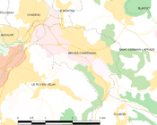 Brives-Charensac só͘-chāi tē-tô͘ | |||
 Brives-Charensac Brives-Charensac tī Hoat-kok ê tāi-lio̍k ūi-tì | |||
Keng-hūi-tō͘: 45°2′48″N 3°55′36″E / 45.04667°N 3.92667°E / 45.04667; 3.92667 | |||
| Kok-ka | |||
|---|---|---|---|
Toā-khu | Auvergne | ||
Koān | Haute-Loire | ||
Kūn | |||

Brives-Charensac sī ūi-tī Hoat-kok Auvergne toā-khu Haute-Loire séng ê chi̍t ê commune.
Tē-lí |
Tī Brives-Charensac ê sì-ûi ū Chadrac, Coubon, Le Monteil, Le Puy-en-Velay, kap Saint-Germain-Laprade téng siâⁿ-chhī he̍k-chiá chng-siā.
Jîn-kháu |
| Nî-tō͘ | 1968 | 1975 | 1982 | 1990 | 1999 | 2007 | 2012 |
|---|---|---|---|---|---|---|---|
| Jîn-kháu | 2,880 | 3,713 | 4,069 | 4,399 | 4,356 | 4,111 | 4,275 |
| Bi̍t-tō͘ (jîn-kháu/km²) | 591.4 | 762.4 | 835.5 | 903.3 | 894.5 | 844.1 | 877.8 |
Chham-khó |
"Commune de Brives-Charensac (43041) - Dossier complet". INSEE. 2016-05-24 khòaⁿ--ê.
Lūi-pia̍t:
- Haute-Loire ê commune
(RLQ=window.RLQ||[]).push(function()mw.config.set("wgPageParseReport":"limitreport":"cputime":"0.140","walltime":"0.199","ppvisitednodes":"value":877,"limit":1000000,"ppgeneratednodes":"value":0,"limit":1500000,"postexpandincludesize":"value":17403,"limit":2097152,"templateargumentsize":"value":1673,"limit":2097152,"expansiondepth":"value":12,"limit":40,"expensivefunctioncount":"value":3,"limit":500,"unstrip-depth":"value":0,"limit":20,"unstrip-size":"value":0,"limit":5000000,"entityaccesscount":"value":0,"limit":400,"timingprofile":["100.00% 163.508 1 -total"," 59.79% 97.755 1 Pang-bô͘:Infobox_French_commune"," 57.67% 94.293 1 Pang-bô͘:Infobox_settlement"," 38.21% 62.481 1 Pang-bô͘:Cite_web"," 22.37% 36.583 1 Pang-bô͘:Location_map"," 9.32% 15.241 1 Pang-bô͘:Geobox_coor"," 7.13% 11.654 1 Pang-bô͘:Coord"," 6.44% 10.527 1 Pang-bô͘:Flag"," 4.49% 7.343 1 Pang-bô͘:Country_data_Hoat-kok"," 1.82% 2.983 1 Pang-bô͘:HauteLoire-geo-stub"],"scribunto":"limitreport-timeusage":"value":"0.047","limit":"10.000","limitreport-memusage":"value":4280932,"limit":52428800,"cachereport":"origin":"mw1301","timestamp":"20190916142824","ttl":2592000,"transientcontent":false););"@context":"https://schema.org","@type":"Article","name":"Brives-Charensac","url":"https://zh-min-nan.wikipedia.org/wiki/Brives-Charensac","sameAs":"http://www.wikidata.org/entity/Q507820","mainEntity":"http://www.wikidata.org/entity/Q507820","author":"@type":"Organization","name":"u7dadu57fau5a92u9ad4u5c08u6848u8ca2u737bu8005","publisher":"@type":"Organization","name":"Wikimedia Foundation, Inc.","logo":"@type":"ImageObject","url":"https://www.wikimedia.org/static/images/wmf-hor-googpub.png","datePublished":"2015-10-29T08:40:01Z","dateModified":"2017-03-05T06:08:31Z","image":"https://upload.wikimedia.org/wikipedia/commons/a/ad/Brives-Charensac_%28Haute-Loire%2C_Fr%29%2C_l%27%C3%A9glise.JPG"(RLQ=window.RLQ||[]).push(function()mw.config.set("wgBackendResponseTime":125,"wgHostname":"mw1326"););


