Arrondissement of Cosne-Cours-sur-Loire Contents History | Geography | Composition | Related pages | References | Navigation menu"Historique de la Nièvre""Arrondissement de Cosne-Cours-sur-Loire (584)""Régions, départements, arrondissements, cantons et communes""Décret n° 2014-184 du 18 février 2014 portant délimitation des cantons dans le département de la Nièvre""Arrondissement de Cosne-Cours-sur-Loire (584)"47°24′44″N 2°55′39″E / 47.41222°N 2.92750°E / 47.41222; 2.92750
Arrondissements of France
arrondissementNièvreBourgogne-Franche-ComtéregioncapitalCosne-Cours-sur-LoireYonneBurgundyClamecyNeversCherCentre-Val de Loirepopulation densityINSEE codes
Arrondissement of Cosne-Cours-sur-Loire
Jump to navigation
Jump to search
Arrondissement of Cosne-Cours-sur-Loire | |
|---|---|
Arrondissement of France | |
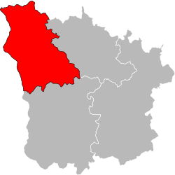
 Location of the arrondissement Cosne-Cours-sur-Loire | |
| Country | France |
| Region | Bourgogne-Franche-Comté |
| Department | Nièvre |
| Communes | 63 |
| Subprefecture | Cosne-Cours-sur-Loire |
| INSEE code | 584 |
| Area | |
| • Total | 1,403.3 km2 (541.8 sq mi) |
| Population (2014) | |
| • Total | 44,772 |
| • Density | 32/km2 (83/sq mi) |
The arrondissement of Cosne-Cours-sur-Loire is an arrondissement of France. It is part of the Nièvre département in the Bourgogne-Franche-Comté region. Its capital is the city of Cosne-Cours-sur-Loire.
Contents
1 History
2 Geography
3 Composition
3.1 Cantons
3.2 Communes
4 Related pages
5 References
History |
When the Nièvre department was created on 17 February 1800, the arrondissement of Cosne-Cours-sur-Loire was part of that original department, with the original name of Cosne. In 1952, the name was changed to Cosne-sur-Loire, and in 1973, after the commune Cours was joined to the commune Cosne-sur-Loire, the name was changed to the present name.[1]
Geography |
The arrondissement of Cosne-Cours-sur-Loire is bordered to the north by the Yonne (Burgundy) department, to the east by the arrondissement of Clamecy, to the south by the arrondissement of Nevers and to the west by the Cher (Centre-Val de Loire) department.
It is the westernmost of the arrondissements of the department, with an area of 1,403.3 km2 (541.8 sq mi).[2] It has 44,772 inhabitants and a population density of 30.6 inhabitants/km².[3]
Composition |
Cantons |
After the reorganisation of the cantons in France,[4] cantons are not subdivisions of the arrondissements so they could have communes that belong to different arrondissements.
There are only 3 cantons in the arrondissement of Cosne-Cours-sur-Loire:
- La Charité-sur-Loire
- Cosne-Cours-sur-Loire
- Pouilly-sur-Loire
Communes |
The arrondissement of Cosne-Cours-sur-Loire has 63 communes; they are (with their INSEE codes):[5]
Alligny-Cosne (58002)
Annay (58007)
Arbourse (58009)
Arquian (58012)
Arthel (58013)
Arzembouy (58014)
Beaumont-la-Ferrière (58027)
Bitry (58033)
Bouhy (58036)
Bulcy (58042)
La Celle-sur-Loire (58044)
La Celle-sur-Nièvre (58045)
Cessy-les-Bois (58048)
Champlemy (58053)
Champvoux (58056)
La Charité-sur-Loire (58059)
Chasnay (58061)
Châteauneuf-Val-de-Bargis (58064)
Chaulgnes (58067)
Ciez (58077)
Colméry (58081)
Cosne-Cours-sur-Loire (58086)
Couloutre (58089)
Dampierre-sous-Bouhy (58094)
Dompierre-sur-Nièvre (58101)
Donzy (58102)
Garchy (58122)
Giry (58127)
Lurcy-le-Bourg (58147)
La Marche (58155)
Menestreau (58162)
Mesves-sur-Loire (58164)
Montenoison (58174)
Moussy (58184)
Murlin (58186)
Myennes (58187)
Nannay (58188)
Narcy (58189)
Neuvy-sur-Loire (58193)
Oulon (58203)
Perroy (58209)
Pougny (58213)
Pouilly-sur-Loire (58215)
Prémery (58218)
Raveau (58220)
Saint-Amand-en-Puisaye (58227)
Saint-Andelain (58228)
Saint-Aubin-les-Forges (58231)
Saint-Bonnot (58234)
Sainte-Colombe-des-Bois (58236)
Saint-Laurent-l'Abbaye (58248)
Saint-Loup (58251)
Saint-Malo-en-Donziois (58252)
Saint-Martin-sur-Nohain (58256)
Saint-Père (58261)
Saint-Quentin-sur-Nohain (58265)
Saint-Vérain (58270)
Sichamps (58279)
Suilly-la-Tour (58281)
Tracy-sur-Loire (58295)
Tronsanges (58298)
Varennes-lès-Narcy (58302)
Vielmanay (58307)
The communes with more inhabitants in the arrondissement are:
| INSEE code | Commune | Population[3] (2014) | Canton | Intercommunality |
|---|---|---|---|---|
| 58086 | Cosne-Cours-sur-Loire | 10,553 | Cosne-Cours-sur-Loire | Loire, Vignobles et Nohain |
| 58059 | La Charité-sur-Loire | 5,008 | La Charité-sur-Loire | Loire, Nièvre et Bertranges |
| 58218 | Prémery | 1,882 | La Charité-sur-Loire | Loire, Nièvre et Bertranges |
| 58215 | Pouilly-sur-Loire | 1,697 | Pouilly-sur-Loire | Loire, Vignobles et Nohain |
| 58102 | Donzy | 1,600 | Pouilly-sur-Loire | Loire, Vignobles et Nohain |
| 58193 | Neuvy-sur-Loire | 1,519 | Pouilly-sur-Loire | Loire, Vignobles et Nohain |
| 58067 | Chaulgnes | 1,476 | La Charité-sur-Loire | Loire, Nièvre et Bertranges |
| 58227 | Saint-Amand-en-Puisaye | 1,306 | Pouilly-sur-Loire | Puisaye-Forterre |
| 58261 | Saint-Père | 1,130 | Cosne-Cours-sur-Loire | Loire, Vignobles et Nohain |
Related pages |
- Arrondissements of the Nièvre department
- Communes of the Nièvre department
References |
↑ "Historique de la Nièvre". Le SPLAF (in French). Retrieved 7 October 2014..mw-parser-output cite.citationfont-style:inherit.mw-parser-output .citation qquotes:"""""""'""'".mw-parser-output .citation .cs1-lock-free abackground:url("//upload.wikimedia.org/wikipedia/commons/thumb/6/65/Lock-green.svg/9px-Lock-green.svg.png")no-repeat;background-position:right .1em center.mw-parser-output .citation .cs1-lock-limited a,.mw-parser-output .citation .cs1-lock-registration abackground:url("//upload.wikimedia.org/wikipedia/commons/thumb/d/d6/Lock-gray-alt-2.svg/9px-Lock-gray-alt-2.svg.png")no-repeat;background-position:right .1em center.mw-parser-output .citation .cs1-lock-subscription abackground:url("//upload.wikimedia.org/wikipedia/commons/thumb/a/aa/Lock-red-alt-2.svg/9px-Lock-red-alt-2.svg.png")no-repeat;background-position:right .1em center.mw-parser-output .cs1-subscription,.mw-parser-output .cs1-registrationcolor:#555.mw-parser-output .cs1-subscription span,.mw-parser-output .cs1-registration spanborder-bottom:1px dotted;cursor:help.mw-parser-output .cs1-ws-icon abackground:url("//upload.wikimedia.org/wikipedia/commons/thumb/4/4c/Wikisource-logo.svg/12px-Wikisource-logo.svg.png")no-repeat;background-position:right .1em center.mw-parser-output code.cs1-codecolor:inherit;background:inherit;border:inherit;padding:inherit.mw-parser-output .cs1-hidden-errordisplay:none;font-size:100%.mw-parser-output .cs1-visible-errorfont-size:100%.mw-parser-output .cs1-maintdisplay:none;color:#33aa33;margin-left:0.3em.mw-parser-output .cs1-subscription,.mw-parser-output .cs1-registration,.mw-parser-output .cs1-formatfont-size:95%.mw-parser-output .cs1-kern-left,.mw-parser-output .cs1-kern-wl-leftpadding-left:0.2em.mw-parser-output .cs1-kern-right,.mw-parser-output .cs1-kern-wl-rightpadding-right:0.2em
↑ "Arrondissement de Cosne-Cours-sur-Loire (584)". Comparateur de territoire (in French). Institut national de la statistique et des études économiques - INSEE. Retrieved 12 June 2017.
↑ 3.03.1 "Régions, départements, arrondissements, cantons et communes" (PDF). Populations légales 2014 (in French). Institut national de la statistique et des études économiques - INSEE. Retrieved 12 June 2017.
↑ "Décret n° 2014-184 du 18 février 2014 portant délimitation des cantons dans le département de la Nièvre" (in French). Legifrance.gouv.fr. 18 February 2014. Retrieved 3 November 2016.
↑ "Arrondissement de Cosne-Cours-sur-Loire (584)" (in French). Institut national de la statistique et des études économiques - INSEE. Retrieved 12 June 2017.
Coordinates: 47°24′44″N 2°55′39″E / 47.41222°N 2.92750°E / 47.41222; 2.92750
Category:
- Arrondissements of France
(RLQ=window.RLQ||[]).push(function()mw.config.set("wgPageParseReport":"limitreport":"cputime":"0.380","walltime":"0.486","ppvisitednodes":"value":3422,"limit":1000000,"ppgeneratednodes":"value":0,"limit":1500000,"postexpandincludesize":"value":23208,"limit":2097152,"templateargumentsize":"value":2445,"limit":2097152,"expansiondepth":"value":27,"limit":40,"expensivefunctioncount":"value":0,"limit":500,"unstrip-depth":"value":1,"limit":20,"unstrip-size":"value":15093,"limit":5000000,"entityaccesscount":"value":1,"limit":400,"timingprofile":["100.00% 441.087 1 -total"," 50.36% 222.142 1 Template:Infobox_French_arrondissement"," 49.55% 218.551 1 Template:Infobox_settlement"," 34.20% 150.861 1 Template:Infobox"," 28.93% 127.592 1 Template:Reflist"," 26.44% 116.632 5 Template:Cite_web"," 9.31% 41.062 4 Template:Main_other"," 9.30% 41.029 1 Template:Coord"," 8.45% 37.266 2 Template:Infobox_settlement/metric"," 7.38% 32.561 2 Template:Convert"],"scribunto":"limitreport-timeusage":"value":"0.173","limit":"10.000","limitreport-memusage":"value":5113294,"limit":52428800,"cachereport":"origin":"mw1338","timestamp":"20191118024826","ttl":2592000,"transientcontent":false););"@context":"https://schema.org","@type":"Article","name":"Arrondissement of Cosne-Cours-sur-Loire","url":"https://simple.wikipedia.org/wiki/Arrondissement_of_Cosne-Cours-sur-Loire","sameAs":"http://www.wikidata.org/entity/Q701061","mainEntity":"http://www.wikidata.org/entity/Q701061","author":"@type":"Organization","name":"Contributors to Wikimedia projects","publisher":"@type":"Organization","name":"Wikimedia Foundation, Inc.","logo":"@type":"ImageObject","url":"https://www.wikimedia.org/static/images/wmf-hor-googpub.png","datePublished":"2014-11-08T01:39:07Z","dateModified":"2017-06-13T17:40:19Z","image":"https://upload.wikimedia.org/wikipedia/commons/f/f2/Ni%C3%A8vre_-_Cosne-Cours-sur-Loire_arrondissement.svg","headline":"arrondissement of France"(RLQ=window.RLQ||[]).push(function()mw.config.set("wgBackendResponseTime":104,"wgHostname":"mw1264"););